 Utah Land Records
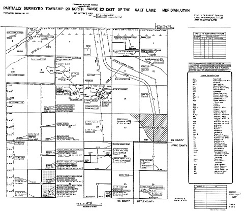
Master Title Plat (MTP) Sample
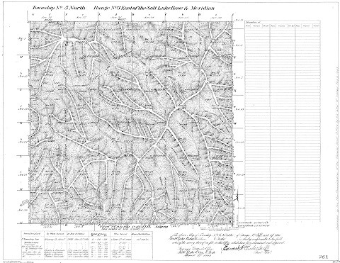
Cadastral Survey Plat Sample
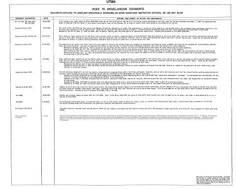
Index to Misc Docs
Searching for Plats
This site has been re-designed to search for all types of plats and supporting documents Master Title Plats, Historical Index Sheets, Cadastral Surveys, Survey Field Notes, Mineral Surveys and Homestead Entries and Control Document Index cards (CDI's). The plats you will find in this site are the same plats that are located in the Public Room of the Bureau of Land Management Utah State Office.
Title Records
Master Title Plats, Use Plats and Historical Indices are known as Title Records. Master Title Plats and Use Plats are a composite diagram for a given township on which is depicted basic cadastral survey information, ownership information (private patent lands, Federal lands, etc.), land status information (withdrawals, restrictions, etc.), and use authorizations. Historical Indices provide a history of the land status by identifying all past and present actions that affect title to Federal lands recorded in chronological order. At first, users might find this system confusing, but armed with a few basic rules, terminology and symbols; the records can be easily interpreted. To learn how to read a Master Title or Use Plat, view this Sample MTP Image.
Cadastral Survey Records
Cadastral Surveys create, mark, define, retrace or reestablish the boundaries and subdivisions of the public lands of the United States. Cadastral Surveys are the foundation upon which rest title to all land that is now, or once was, Public Domain of the United States. The official record of these surveys are plats and field notes representing Rectangular Surveys, Mineral Surveys and Homestead Entry Surveys.
Records Improvement Project
In 2001, the BLM initiated a records improvement project to improve not only the physical conditions of the records but to also increase the accuracy, reliability, timeliness and access to the BLM’s official Public Land Records. Beginning in 2001, all Master Title Plats, Use Plats and Historical Indices were scanned and stored in a digital format. These digital records have been designated the official agency records. Since October 2002, records have been updated in a digital environment using computer aided drafting and graphic editing software. Records are stored on the computer as images and are accessible from the world wide web.
The current title records system was initiated in 1955 as a replacement for the earlier system of tract books. Master Title and Use Plats, and Historical Indices were drafted on vellum and Mylar material with pen and ink. Over the years these records showed signs of deterioration from over handling and environmental factors, such as heat and ultraviolet light.
In 2003, the BLM began scanning survey plats. Currently all of BLM Utah's official Cadastral survey plats, as well as Cadastral survey field notes from October 1, 1998 to the present are accessible through the Public Land Records web site. In the future, all of the survey field notes dating back to 1850 will be available.
Search by Township & Range
The MTP's and HI's are stored by quadrant of the state NE, NW, SE, and SW, within the survey merdian where they are located. The Salt Lake Meridan (SLM) and Uintah Special Merdian (USM) are separated so images with the same number i.e. T.1N., R.1E. will not be confused. Selecting the correct meridian is critical to locating the right plat. Within the two meridian, there are 2430 townships in the SLM and 138 townships in the USM.
Once you have entered the Meridian, Township and Range, you will be able to select the type of plat or file that you are interested in viewing (i.e. Master Title Plats (MTP), Historical Index (HI), Use, Control Document Index (CDI) Rectangular Surveys or ALL) that have been scanned in your selected township and range. There can be as many as 30 or 40 plats within these tables.
Some important information to know about Special Surveys:
Mineral Survey Office Numbers vs Mineral Survey (Lot) Numbers
Early mineral surveys in Utah were numbered to be unique within each mining district. Because there are many mining districts, this practice created several mineral surveys within Utah with the same name such as Mineral Survey No.37. Around 1895, the General Land Office decided to make the numbering system unique within the state rather than individual districts and reassigned Mineral Survey Office Numbers to existing Mineral Survey (lot) Numbers. Mineral Survey Numbers and Mineral Survey Office Numbers are identical after about 1895 The mineral connection sheets for the mining districts show, in most cases, two numbers for the pre-1895 mineral surveys. The Mineral Survey Office Number must be used when querying the land records site. Refer to the appropriate mineral connection sheet to obtain a Mineral Survey Office Number of a particular mineral survey.
Patent Numbers vs General Land Office Numbers
Before July 1, 1908, the General Land Office (GLO) assigned reference numbers in the upper left-hand corner of each patent document. No official patent numbers were being assigned at that time. After this date, patent numbers were assigned consecutively and should appear in the upper right-hand corner of the patent. Some earlier mineral survey plats have a GLO reference number referring to the patent instead of official patent number.
Standard Image File Name UT260090N0150E0-1001.tif
The Standard Image file name above, was developed by the BLM Scanning Specification Committee. The file name consists of 15 characters. The first two characters UT
are the two letter state abbreviation. i.e. UT = Utah. The third and fourth characters 26
are the two digit Meridian Code. i.e. 26 = SLM and 30 = USM. The fifth, sixth and seventh characters 009
are the three digit Township number, with leading zeros for township of single digits. The eighth character 0
is for fractional townships, 0
is no fraction, 2 is for ½ townships. The ninth character N
is the township direction, N = North, and S = South. The tenth, eleventh and twelth characters 015
are the three digit Range number, with leading zeros for ranges of single digits. The thirteenth character 0
is for tractional ranges, 0
is no fraction, 2 is for ½ ranges. The fourteenth character E
is the range direction, E = East and W = West. The fifteenth character 0
is duplicate townships, 0
is for no duplicate and 2
indicates the second of two duplicate township. The four characters after the dash are the Plat Type Code and Plat Page Number.
Plat Type Codes UT260090N0150E0-1001.tif
The Plat Type Code is the last 4 digits of the image name. It can be identified easily because it is separate for the rest of the image name by a -
. The 4 digit code is broken down into two part: the first two digits 10
are the plat type, the second 2 digits 01
are the Page Number for that plat type. A Plat Type Code of 1001 is the first page of the MTP, and for MTPs that is the only page number available. Historical Index sheets on the other hand may have numerous pages, some townships have as many as 30 HI pages. The following is a table of all the Plat Type Codes used in Utah.
| Plat Type | Plat Type Code | Plat Type Abbrev. |
|---|---|---|
| Master Title Plat | 10 | MTP |
| Supplemental MTP | 11 | SUPP |
| Historical Index | 20 | HI |
| Acquired Land HI | 21 | ACQD |
| Mineral Loaction HI | 25 | ML |
| Master Title - Use | 40 | MTU |
| Supplemental Use | 41 | SUPUS |
| Gilsonite | 50 | GL |
| Supplemental Gilsonite | 51 | SUPGL |
| Oil & Gas | 60 | OG |
| Supplemental O & G | 61 | SUPOG |
| Oil Shale | 65 | OS |
| GeoThermal | 70 | GO |
| Supplemental GeoThermal | 71 | SUPGO |
| Coal | 80 | CO |
| Supplemental Coal | 81 | SUPCO |
| Potash | 85 | PO |
| Supplemental Potash | 86 | SUPPO |
| Mineral | 90 | MN |
| Supplemental Mineral | 91 | SUPMN |
Master Title Plat Symbols and Notation
| FEATURE | SYMBOL | USAGE |
|---|---|---|
| SINGLE PATENT LINE |  | Line is heavy on the side of the property line that is patented. This same line type is used to depict Public Sales, State Grants, Warranty Deeds, Railroad Grants, and Allotments. (See Notations on the plats for specific use.) |
| DOUBLE PATENT LINE |  | Line is heavy on both sides of the property line, indicating a patent on both sides of the line |
| SECTION LINE & SURVEY LINE |  | Used on the all lines of the township that are surveyed. this same line type is used to depict, Tract Lines, Mineral Surveys, Homestead Surveys and Acquired Lands |
| LOT TICS |  | Lot tics appear in different position as shown depending on the configuration of the surveyed lots. |
| WITHDRAWAL, CLASSIFICATION, RESERVES, INTERNATIONAL BOUNDARIES, RECREATION AND PUBLIC PURPOSE (R&PP) |  | Line is used to depict land uses mentioned and is offset to the inside on the land boundary of the parcel they identify. |
| LEASE LINE, USE PERMIT AND AVIATION SITE |  | Line is used to depict land uses mentioned and is offset to the inside of the land boundary of the parcel they identify. |
| DESIGNATION AREA |  | Line is used to depict a Designation Area and is offset to the inside of the land boundary of the parcel it identifies. |
| STATE BOUNDARY LINE |  | Line is used to depict the State Boundary. |
| FIELD OFFICE BOUNDARY O & C BOUNDARY CWR BOUNDARY |  | Used to depict the boundary line of the aforementioned boundary lines. |
| PIPE LINE OR CONDUIT |  | Symbol depicts any underground pipe line the size and type will be noted. |
| UNIMPROVED ROAD |  | Road way width will be noted, symbol is drawn at 50 ft. width. |
| IMPROVED ROAD |  | Improved Road with will be noted symbol is drawn at 50 ft. width. |
| TRAIL OR FIREBREAK |  | Symbol will be used for both designations, but correct designation will be noted. |
| CORRIDOR (R/W'S) |  | Symbol depicts a corridor for multiple use R/W's. |
| RAILROAD OR TRAMWAY |  | Symbol depicts a railroad R/W. The width and number of tracks will be noted. |
| POWER TRANSMISSION LINE |  | Symbol depicts a power line. The R/W width and Line Voltage will be noted. |
| TELEPHONE LINE |  | Symbol depicts a telephone line. R/W width and number of lines will be noted. |
| TELEPHONE & TELEGRAPH |  | Symbol depicts a telephone and telegraph line. R/W width and number of line will be note. |
| TELEGRAPH LINE |  | Symbol depicts a telegraph line. R/W width and number of line will be noted. |
| DITCH, CANAL, FLUME OR AQUEDUCT |  | Symbol depicts a ditch, canal, flume or aqueduct. The arrows indicate the direction of the flow. |
| UNSURVEYED LINE |  | Symbol dpects a area that is unsurveyed. The slanted line are inside the unsurveyed area. |